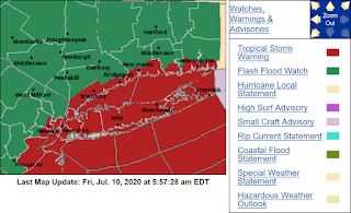
current location at 10:38 UTC
Update (7/11/2020): The storm went west of my area, so I only got about 0.2" of rain.
Tropical Storm Fay Local Statement Advisory Number 3
CTZ009>012-NJZ006-106-108-NYZ071>075-078>081-176>179-101730-
Tropical Storm Fay Local Statement Advisory Number 3
National Weather Service New York NY AL062020
527 AM EDT Fri Jul 10 2020
This product covers Southeast New York, Northeast New Jersey, and Southern Connecticut
**TROPICAL STORM FAY TO BRING HEAVY RAINFALL, STRONG WINDS, AND DANGEROUS SURF CONDITIONS**
* STORM INFORMATION:
- About 240 miles south of New York City NY or about 300 miles
south-southwest of Montauk Point NY
- 37.4N 74.8W
- Storm Intensity 50 mph
- Movement North or 360 degrees at 10 mph
SITUATION OVERVIEW
------------------
Tropical Storm Fay, located just east of the southern Delmarva Peninsula, will move northward along the coast towards the area today, making landfall near the New York City area tonight. The main threats with this system will be locally heavy rainfall, the potential for flash flooding, and dangerous surf conditions today into tonight.
PRECAUTIONARY/PREPAREDNESS ACTIONS
----------------------------------
Now is the time to complete all preparations to protect life and property in accordance with your emergency plan. Make sure you are in a safe location before the onset of strong winds or possible flooding.
Keep cell phones well charged. Cell phone chargers for automobiles can be helpful, but be aware of your risk for deadly carbon monoxide poisoning if your car is left idling in a garage or other poorly ventilated area.
Rapidly rising flood waters are deadly. If you are in a flood prone area, consider moving to higher ground. Never drive through a flooded roadway. Remember, Turn Around Don't Drown! If a Tornado Warning is issued for your area, be ready to shelter quickly, preferably away from windows and in an interior room not prone to flooding. If driving, scan the roadside for quick shelter options.
If in a place that is vulnerable to high winds, such as near large trees, a mobile home, upper floors of a high rise building, or on a boat, consider moving to a safer shelter before the onset of strong winds or flooding.
Closely monitor http://weather.gov, NOAA Weather radio or local news outlets for official storm information. Be ready to adapt to possible changes to the forecast. Ensure you have multiple ways to receive weather warnings.
* ADDITIONAL SOURCES OF INFORMATION:
- For information on appropriate preparations see http://ready.gov
- For information on creating an emergency plan see http://getagameplan.org
- For additional disaster preparedness information see http://redcross.org
NEXT UPDATE
-----------
The next local statement will be issued by the National Weather Service in New York NY around 12 PM EDT, or sooner if conditions warrant.


...oh how I hope to get some rain!
ReplyDeleteAnd Massachusetts is in the warning, too. The amount of rain 1 - 2 inches for some areas of MA should help with the drought. Take care.
ReplyDeleteThis morning on the news, it sounded like you should put your umbrellas away, but your patio furniture should be safe. Sounds far more ominous than what they were saying at 5 am this morning.
ReplyDeleteThis sounds very scary.
ReplyDeleteI hope you get through this OK!
Boring ole Germany luckily does not have these extremes.
Fingers and toes crossed for you, Mielebaer has his paws tight, too.
Keep us updated...